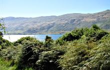
Home / Tracks / Te Kere Haka Track DOC Track · Otago · Easy Te Kere Haka Track Located in Kingston area The Te Kere Haka Track follows the shore of Lake Wakatipu. Location Open in Google Maps for driving directions → Map requires JavaScript. Open this location in Google Maps . Nearby on conservation land Shirt Tail Track track · 0.8 km · Otago Garston Ski Hut hut · 14.8 km · Otago Two Mile Hut hut · 17.7 km · Otago Cowshed Hut hut · 20.0 km · Southland Lower Wye Creek Track track · 21.0 km · Otago Beech Hut hut · 22.3 km · Southland What you can do here Walking and tramping Official information Track conditions, closures, and detailed maps are managed by the New Zealand Department of Conservation. View Te Kere Haka Track on doc.govt.nz →